Log in
All resources
Create a design
5,084 Free Artworks of Pages With Maps
national library of poland
maps from the earth and its inhabitants, vol. iv
vrbivm praecipvarvm mvndi theatrvm qvintvm (1617)
australia (1873) by booth
maps from the earth and its inhabitants, vol. ix
19th-century maps of kent
the cruise of the marchesa (1889)
maps from the earth and its inhabitants, vol. xiii
maps from the earth and its inhabitants, vol. x
cavite e santiago (1898)
maps from the earth and its inhabitants, vol. iv
sewers in london
the cruise of the marchesa (1889)
martes zibellina
géographie générale; physique, politique et économique (1876)
old maps of the pyrenees
maps from the earth and its inhabitants, vol. xv
19th-century maps of central america
maps from the earth and its inhabitants, vol. iv
romney marsh
maps from the earth and its inhabitants, vol. xvi
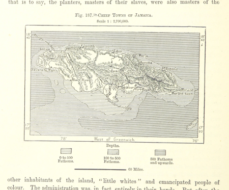
19th-century maps of jamaica
maps from the earth and its inhabitants, vol. xiii
19th-century maps of namibia
maps from the earth and its inhabitants, vol. xiii
1878 maps of africa
maps from the earth and its inhabitants, vol. x
khedivate of egypt
maps from the earth and its inhabitants, vol. xiii
19th-century maps of madagascar
maps from the earth and its inhabitants, vol. iv
firth of inverness
maps from the earth and its inhabitants, vol. vi
topographic maps of asia
maps from the earth and its inhabitants, vol. xiv
maps of voyages
maps from the earth and its inhabitants, vol. xvii
1870s maps of florida
maps from the earth and its inhabitants, vol. x
john hanning speke
maps from the earth and its inhabitants, vol. vi
maps of kerch
maps from the earth and its inhabitants, vol. iv
rhins of galloway
maps from the earth and its inhabitants, vol. iv
isle of thanet
19th-century maps of nicaragua
1870s maps of central america
19th-century maps of somalia
1876 maps of africa
nouveau cours d'instruction primaire de géographie (1886)
maps of tahiti
maps in the library of congress
1838 maps
the earth and its inhabitants, vol. ix: asia, vol. iv
vrbivm praecipvarvm mvndi theatrvm qvintvm (1617)
maps of castelnuovo by braun & hogenberg
vrbivm praecipvarvm mvndi theatrvm qvintvm (1617)
maps of zahara by braun & hogenberg
vrbivm praecipvarvm mvndi theatrvm qvintvm (1617)
maps of cártama by braun & hogenberg
vrbivm praecipvarvm mvndi theatrvm qvintvm (1617)
maps of sarrebourg by braun & hogenberg
vrbivm praecipvarvm mvndi theatrvm qvintvm (1617)
maps of tønder by braun & hogenberg
vrbivm praecipvarvm mvndi theatrvm qvintvm (1617)
maps of tours by braun & hogenberg
vrbivm praecipvarvm mvndi theatrvm qvintvm (1617)
maps of husum by braun & hogenberg
vrbivm praecipvarvm mvndi theatrvm qvintvm (1617)
maps of lyon by braun & hogenberg
atlas minor gerardi mercatoris (1609)
maps of europe by mercator-hondius
maps from the mechanical curator collection available to georeference
maps from the mechanical curator collection
arnold's geographical handbook (1899)
global maps of climate zones
vrbivm praecipvarvm mvndi theatrvm qvintvm (1617)
maps of acquapendente by braun & hogenberg
kadasterkaarten maastricht (ca 1823-1830)
1830 maps
the cruise of the marchesa (1889)
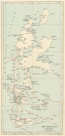
19th-century maps of the moluccas
john rocque's 1748 map of london and adjacent country
a history of london (1884)
19th-century maps of new south wales
australia (1873) by booth
19th-century maps of victoria, australia
australia (1873) by booth
vrbivm praecipvarvm mvndi theatrvm qvintvm (1617)
maps of hildesheim by braun & hogenberg
vrbivm praecipvarvm mvndi theatrvm qvintvm (1617)
maps of münstermaifeld by braun & hogenberg
vrbivm praecipvarvm mvndi theatrvm qvintvm (1617)
maps of montlhéry by braun & hogenberg
vrbivm praecipvarvm mvndi theatrvm qvintvm (1617)
maps of visegrád by braun & hogenberg
vrbivm praecipvarvm mvndi theatrvm qvintvm (1617)
maps of heide by braun & hogenberg
arnold's geographical handbook (1899)
maps of ocean currents
1890s maps of the atlantic ocean
cavite e santiago (1898)
great explorers of africa (1894)
ghosts & ghoulish scenes
john rocque's 1748 map of london and adjacent country
a history of london (1884)
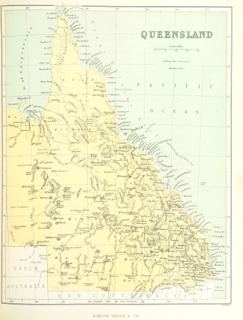
19th-century maps of queensland
australia (1873) by booth
our arctic province, alaska and the seal islands (1886)
old maps of alaska
our arctic province, alaska and the seal islands (1886)
old maps of alaska
the cruise of the marchesa (1889)
19th-century maps of sulawesi
in the volcanic eifel. a holiday ramble (1896)
old maps of eifel
19th-century maps of tasmania
australia (1873) by booth
19th-century maps of south australia
australia (1873) by booth
in the volcanic eifel. a holiday ramble (1896)
old maps of eifel
geographia universalis (1545) in the british museum
german renaissance,northern renaissance
geographia universalis (1545) in the british museum
german renaissance,northern renaissance
cavite e santiago (1898)
1898 maps of cuba
cavite e santiago (1898)
1898 maps of cuba
john and sebastian cabot. a study (1886)
reconstructions of old maps
maps of crossings of the atlantic ocean
physical geography (1899) by davis
ghosts & ghoulish scenes
maps from the earth and its inhabitants, vol. xv
circumpolar maps
maps from the earth and its inhabitants, vol. iv
1870s maps of london
maps from the earth and its inhabitants, vol. iv
old maps of the isle of arran
maps from the earth and its inhabitants, vol. iv
19th-century maps of kent
maps from the earth and its inhabitants, vol. v
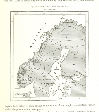
maps of scandinavia
maps from the earth and its inhabitants, vol. xvii
maps of minneapolis
maps from the earth and its inhabitants, vol. viii
maps of india
maps from the earth and its inhabitants, vol. ix
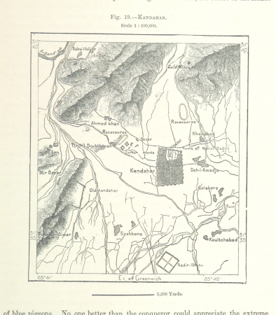
maps of kandahar
maps from the earth and its inhabitants, vol. xi
maps of benghazi
maps from the earth and its inhabitants, vol. v
maps of scandinavia
maps from the earth and its inhabitants, vol. viii
maps of india
atlas ou representation du monde universel t. 2 (1633)
maps by hendrik hondius the younger
maps from the earth and its inhabitants, vol. iv
old maps of edinburgh
maps from the earth and its inhabitants, vol. iv
old maps of leeds
maps from the earth and its inhabitants, vol. iv
old maps of lindisfarne
maps from the earth and its inhabitants, vol. iv
old maps of hastings, england
maps from the earth and its inhabitants, vol. iv
old maps of edinburgh
maps from the earth and its inhabitants, vol. iv
old maps of newcastle upon tyne
maps from the earth and its inhabitants, vol. iv
maps of the humber estuary
19th-century maps of senegal
orientalist painting
maps of the battle of the nile
battle of alexandria
the comprehensive history of england (1876)
english-language maps showing history
maps from the earth and its inhabitants, vol. vii
charles eugène perron
the comprehensive history of england (1876)
english-language maps showing history
maps from the earth and its inhabitants, vol. ix
maps of herat
maps from the earth and its inhabitants, vol. v
maps of scandinavia
maps from the earth and its inhabitants, vol. vii
maps of lhasa
maps from the earth and its inhabitants, vol. xiv
maps of australia
maps from the earth and its inhabitants, vol. ix
maps of tehran
maps from the earth and its inhabitants, vol. ix
maps of tehran
maps from the earth and its inhabitants, vol. vii
maps of keelung
maps from the earth and its inhabitants, vol. xvi
maps of mexico
maps from the earth and its inhabitants, vol. x
maps of uganda
maps from the earth and its inhabitants, vol. iii
maps of the rhine
maps from the earth and its inhabitants, vol. ix
maps of the tigris
atlas ou representation du monde universel t. 2 (1633)
1630s maps of virginia
701 - 800 of 5,084
Next page
/ 51


![Gerardi Mercatoris and I. Hondii Atlas or Representation of the Universal World, and of the Parts of It, Made in Tables and Very Ample Descriptions. [t. 2].](https://cdn.creazilla.com/illustrations/10000421870/gerardi-mercatoris-and-i-hondii-atlas-or-representation-of-the-universal-world-and-of-the-parts-of-it-made-in-tables-and-very-ample-descriptions-t-2-sm.jpg)


![Gerardi Mercatoris and I. Hondii Atlas or Representation of the Universal World, and of the Parts of It, Made in Tables and Very Ample Descriptions. [t. 2].](https://cdn.creazilla.com/illustrations/10001569396/gerardi-mercatoris-and-i-hondii-atlas-or-representation-of-the-universal-world-and-of-the-parts-of-it-made-in-tables-and-very-ample-descriptions-t-2-sm.webp)